


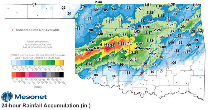
Western Oklahoma – Western Oklahoma has been drenched by one of the region's most significant rainfall events in recent months, with some communities receiving nearly 10 inches of rain in just 24 hours and other locations possibly exceeding that amount.
Multiple rounds of heavy thunderstorms Tuesday night and Wednesday brought widespread flooding concerns across Beckham, Custer, Washita, Roger Mills and Greer counties, prompting the National Weather Service in Norman to issue flash flood warnings, flood warnings and flood watches throughout the region.
According to Oklahoma Mesonet rainfall data as of 3 p.m. Wednesday, October 14, Hinton recorded an impressive 9.2 inches of rain over the previous 24 hours. Elk City followed with 8.5 inches, while Erick received 6.6 inches, Weatherford recorded 6.1 inches and Bessie measured 6 inches.
Those totals represent rainfall accumulated in just one day, with additional precipitation possible before the storm system moves out of the area. Other portions of Beckham, Washita and Custer counties may have received well over 10 inches of rain, although those higher amounts have not yet been officially confirmed.
The extraordinary rainfall quickly overwhelmed drainage systems, filled creeks and streams, and created dangerous driving conditions across western Oklahoma. Low-lying areas and roadways were particularly vulnerable as repeated rounds of thunderstorms moved across already saturated ground.
By Wednesday afternoon, the National Weather Service had issued a flood warning covering eastern Beckham County, Custer County, Washita County, southeastern Roger Mills County and northern Greer County. The warning replaced an earlier flash flood warning as flooding continued across the region.
Communities included in the warning area were Elk City, Weatherford, Clinton, Sayre, Cordell, Burns Flat, Sentinel, Hammon, Canute, Foss and several surrounding towns.
A broader flood watch remained in effect through Thursday afternoon as forecasters warned that additional rainfall could worsen flooding conditions. Rivers, creeks and streams were expected to continue responding to the significant runoff, with a river flood warning also issued for the Washita River near Clinton.
The heavy rainfall comes as welcome moisture for western Oklahoma agricultural producers, particularly those preparing fields or establishing winter wheat. However, the excessive amounts falling over such a short period could also create problems, including saturated fields, soil erosion and delays in fall fieldwork.
The National Weather Service continued to urge motorists to avoid flooded roads and low-water crossings, reminding drivers that even relatively shallow moving water can sweep vehicles off roadways.
The unsettled weather pattern is expected to continue into Thursday, with additional showers and thunderstorms possible before a strong cold front brings a dramatic change in conditions.
By Friday, western Oklahoma should begin drying out as cooler air moves into the region. Temperatures around Elk City are forecast to reach only about 60 degrees Friday, with windy conditions and overnight lows dropping into the middle 30s.
The weekend is expected to offer a welcome break from the rain. Saturday should bring mostly sunny skies and highs near 60 degrees, while Sunday will feature partly sunny skies and temperatures in the lower 60s. Morning temperatures will remain chilly, generally ranging from the upper 30s to lower 40s.
Warmer and drier weather is expected to return early next week, with afternoon highs climbing toward 70 degrees by Monday.
After days of torrential rainfall and widespread flooding concerns, the cooler and drier weekend should provide western Oklahoma residents with an opportunity to assess the impact of the storms and begin the cleanup process.
Sources: Oklahoma Mesonet rainfall totals provided as of 3 p.m. October 14, 2026, National Weather Service Norman, and current regional weather forecasts. Rainfall amounts are preliminary.
Copyright 2026 Paragon Communications. All rights reserved. This material may not be published, broadcast, rewritten, or redistributed without permission.



.jpg)