


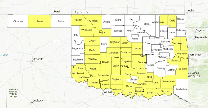
Western Oklahoma – Drought conditions have rapidly intensified across western Oklahoma, prompting several counties to extend burn bans as hot, dry weather continues to increase wildfire concerns.
Washita, Dewey, Greer and Jackson counties extended their county burn bans during meetings of county commissioners Monday. Kiowa and Harmon counties remain under burn bans established last week.
In all, 46 of Oklahoma's 77 counties are currently under county burn bans.
The latest U.S. Drought Monitor, valid Aug. 18 and released Aug. 20, shows a sharp deterioration in conditions across Oklahoma. Every part of the state is now classified as at least abnormally dry, while 94.64 percent is experiencing moderate drought or worse. Severe drought covers 62.21 percent of Oklahoma, and nearly 35 percent of the state is now in extreme drought.
The most serious conditions remain concentrated in western Oklahoma. Large portions of western and southwestern Oklahoma are classified in extreme drought, with areas of exceptional drought, the highest category on the Drought Monitor scale, appearing across portions of western Oklahoma.
Conditions have deteriorated quickly. One week earlier, 28.14 percent of Oklahoma was in extreme drought or worse and only 2.29 percent was experiencing exceptional drought. Those figures have now increased to 34.94 percent and 8.68 percent, respectively.
The Drought Monitor specifically noted that extreme to exceptional drought continues across western Oklahoma. Persistent high pressure over the southern Plains has produced unusually hot temperatures and little rainfall, contributing to what officials describe as flash drought conditions.
The worsening drought is also increasing wildfire concerns.
Oklahoma Forestry Services said Monday was expected to produce the highest fire danger of the week in southwestern Oklahoma. Temperatures across western and southwestern Oklahoma were forecast to reach 100 to 112 degrees, with relative humidity falling into the 20 to 27 percent range. Dry vegetation combined with gusty winds could allow grass fires to spread rapidly.
Forestry officials said grassland fires in western and southwestern Oklahoma could spread at rates of 90 to 135 feet per minute, with flame lengths of 9 to 13 feet. Fires involving a mixture of grass and brush could also produce torching and spotting behavior, making suppression more difficult.
There is at least some opportunity for relief this week, although widespread drought-ending rainfall is not expected.
A cold front moving into Oklahoma will bring scattered opportunities for showers and thunderstorms. Around Elk City, the National Weather Service forecasts a 40 percent chance of showers and thunderstorms Tuesday night, followed by additional 20 percent chances Wednesday night and Thursday. Temperatures are also expected to fall from triple digits Tuesday to the middle and upper 90s Wednesday and Thursday.
Oklahoma Forestry Services cautions that rainfall during the next seven days is expected to remain sparse, with the best chances for widespread wetting rainfall in the Oklahoma Panhandle. Storms associated with two frontal boundaries could provide isolated beneficial rainfall elsewhere, but hot and primarily dry conditions are expected to remain the overall pattern.
Until more substantial rainfall arrives, officials are urging residents to follow county burn-ban restrictions and use extreme caution with any activity capable of producing a spark or flame.
Copyright 2026 Paragon Communications. All rights reserved. This material may not be published, broadcast, rewritten, or redistributed without permission.




.jpg)